

Our India political and culture
Summary
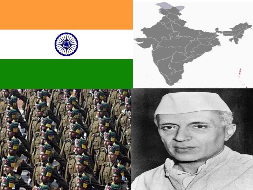
India, our country has its own geographical, historical, political and cultural background. Among the Europeans who came to India, the British ruled for a long period of 200 years. As a result of the fight for freedom from the British rule, India became an independent country on 15th August, 1947. India did not have a definite boundary. But after independence, it has a definite boundary. At present, India is one nation with the union of states. Let us be proud of our great country-India.
Location of India

India is situated in the southern part of Asia, which is the largest continent in the world. Latitudinally India extends from 8o N to 37o N. latitude and longitudinally it extends from 68o E to 97o E longitude. India lies entirely in the Northern Hemisphere and is at the Centre of the Eastern Hemisphere. The Tropic of Cancer(23 ,1 /2 oN), a special latitude, passes through the middle of the country. It divides India into almost two equal parts, North India and South India. Hence India has tropical climate in the southern part of it and subtropical climate in the northern part.
A special latitude which divides the earth into two equal halves is called Equator (0o ). The half of the earth to the north of it is called Northern Hemisphere and to the south of it is called Southern Hemisphere.
Longitudes are imaginary lines drawn on the globe, from the North Pole to the South Pole. They are also known as meridians.
The longitude that passes through Greenwich in England is called the Prime Meridian (0o). The half part of the earth to the east of Prime meridian is called Eastern Hemisphere and to the west of it is called Western Hemisphere.
1)India and its Neighboring Countries

The neighbouring countries of India are – Pakistan and Afghanistan to the north-west, Nepal, Bhutan and China are to the north, Bangladesh and Myanmar to the east and to the south – east is Srilanka. It is an Island and it is separated from India by Palk Strait and the Gulf of Mannar.
Peninsular
Peninsular India is surrounded by the seas and ocean and has 7,516.6 km long coastline. This helps the growth of foreign trade, shipping, fishing and shipbuilding. • The water bodies which surround India are the Bay of Bengal in the east, the Arabian Sea in the west and the Indian Ocean in the south. water bodies surrounding India on three sides. Such a landform is called a peninsula. So South India is a peninsular.A piece of land surrounded by water on all sides is called an island. The Andaman-Nicobar and Lakshadweep are the islands of India.
2)Administrative Divisions of India:–India was ruled by several native dynasties and external forces. The country was fragmented into hundreds of small princely states. After independence, in order to carry on smooth administration, the boundary lines of the states were reorganized. There are a large number of languages in India. This indicates the diversity of languages. Of these, 15 languages have been recognised as official languages and are printed on Indian currency. India is the 7th largest democratic country in the world. It is divided into 29 states and 6 union territories and one National Capital Territory which is Delhi. Since the states are divided on the basis of languages it becomes easy to understand their environment, economic, cultural and regional traditions.
The Government of India is officially known as Central Government. It is the governing authority of the country’s states and union territories. Its main offices are located in New Delhi, the capital of the country. The administration of the states is managed by the states themselves. This system is called State Government.
The union territories are ruled directly by the Central Government. They do not come under any state. The Governor, appointed by the President of India is the administrator for the union territories. There are 6 union territories. They are, DiuDaman, Dadra – Nagara Haveli, Chandigarh, Lakshadweep, Puduchery, Andaman and Nicobar islands.
3)Unity in Diversity and Integration
India is a land of many religions. Hence people follow variety of customs. Hinduism, Islam, Christianity, Sikhism, Buddhism and Jainism, are the major religions of India. Thus, India is a land of many religions.
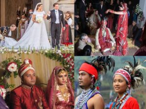
Our occupations, religions, caste systems, languages, food habits, dress, customs and regional culture also have diversity. But we live together as people of one country. This is known as Unity in diversity.
4. National Emblems

The National Flag is one of the national symbols of our country. It is a horizontal rectangular tricolor(Tiranga) of saffron, white and green. Saffron stands for courage and sacrifice, white colour symbolises peace and purity and green is the symbol of fertility. The Ashoka Chakra is at the Centre of the flag. It is the symbol of progress and movements. Our national flag represents India and has a special recognition in the international level. The National Flag, National Emblem, and National Anthem are our National symbols.
Monolith pillar

Monolith pillar at Saranath. The lion seal that you notice here has been adopted as the National
Emblem of India. This pillar was installed during the reign of Ashoka the Great, in North
India.The four facing lion imprint is our National Emblem
It represents the diversity and regionalism of India. While you are singing this national anthem, you feel patriotic.
5. Art, Music and Literature

Every state is identified by its own dance style. It is based on the culture of that locality. Dance styles can help in spreading the glory of India’s heritage in foreign countries. In India, there are different types of dances. You can also practice them. Among the many dance forms in Karnataka, Yakshagana has been selected as an important one.
Music and Literature
India is rich with litterateurs, great artist achievers, saints and monks and social reformers. Every state contributes its own music, literature, art, sports, cinema, science and technology. The Government of India rewards great personalities, by awarding Padmashree, Padmabhushana, Padmavibhushana and Bharath Ratna to acknowledge their achievement in their concerned field.
We should cultivate patriotism. We should all come together in the name of our motherland when needed. India has become an independent country because of its integrity, nonviolence and sacrifice. Let us develop India and make it a strong nation at the global level. It is the responsibility of every Indian to make India a strong nation. Mera Desh Mahan .
Exercise
Answer the following
1.In which part of India is Karnataka state located ?
Ans: Karnataka state is located in south part of India.
2.How many districts are there in Karnataka state? List them.
Ans:There are 20 districts in Karnataka state they are
1.Bangalore
2.Belgaum
3.Mysore
4.Tumkur
5.Gulbarga
6.Bellary
7.Bijapur
8.Dhakshina kannada
9.Devanagere
10.Raichur,
11.Bagalkot
12.Dharwad
13. Mandya
14.Hassan
15.Shimoga
16.Bidar
17.Chitradurga
18. Haveri
19.Kolar
20.Uttar kannada
3.Which are the neighbouring states of Karnataka? Mention.
Ans:Tamil nadu, Kerala, Maharashtra.
4.Which is the official language of our state?
Ans:The official language of our state is Kannada.
5.Which are the languages of your neighbouring states?
Ans:Tdugu, Tamil, Marati ,Malayaum.
6.Which is the language you speak at home?
Ans:Tamil
7.Which is the official language of India?
Ans: Hindi
8.Write the color of national flag.
Ans:Saffron white , Green
9. Write 5 sentence about popular sport in india
Ans: The most popular sport in india is cricket.In cricket we have 2 bats men 9 fielders one bowler, and 1 wicket keeper and two empire.