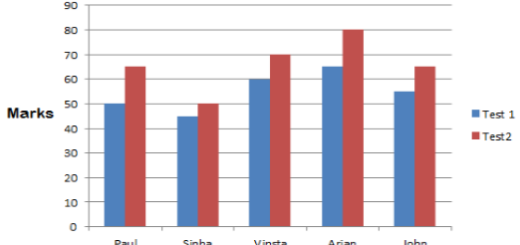

OUR INDIA – PHYSICAL DIVERSITY
Summary of our india Physical diversity
Summary
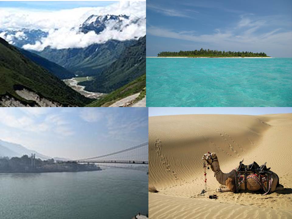
India is our country. It has a variety of physical features such as Himalayan mountain ranges, very high peaks, plateaus, vast plains, river systems, deserts, coastal plains and islands. India-our country, which is unique in its natural setting. India is the home for a variety of plants and animals.
Physical divisions of India
When we look at the map we see various types of land forms such as mountains, hills, plains, plateaus, valleys, gorges etc. These differences, that we see on the land surface are known as physical features.
The major physical divisions of India.
- The Northern Mountains :
They consist mostly of the Himalayan ranges.The northern part of the map you will notice that the Himalayan ranges extend from Kashmir to Meghalaya. The Himalayas are the highest mountains in the world.
Characteristics of the Himalayan ranges
They are covered with snow. Hence they are called
Himalayas.
• They have many high peaks.
• There are many deep valleys and gorges.
• There are glaciers and the highest mountain passes.
• There are hot springs.
• There is a variety of plant and animal species.
Advantages
Himalayas prevent the cold winds from central Asia
blowing into India.
They are the source of many North Indian rivers.
They check the monsoon winds and cause heavy rainfall.
They are like a gigantic wall and are natural northern
frontiers to control foreign invasions.
A mountain range is a group of or chain of mountains
found close together and extend to thousands of kilometes.
2)The Northern Plains :
The Northern plains of India are formed by the deposition of alluvium carried by the rivers while flowing from the Himalayan ranges. These plains are known as Indus, Ganga
and Brahmaputra plains.These plains are situated between the Himalayan mountains
and Peninsular plateaus
Many towns and cities of Harappa civilization have developed on the river banks. Even now there are many famous historical cities and pilgrimage places situated on river banks. On account of
the ideal conditions for settlement many empires ruled in the Northern plains. For example, Maurya, Mughal and Gupta empires. You will learn about this in the higher classes.
The plains are more helpful for the growth of architecture.Since these regions have level land it is easy to construct big buildings. The availability of different types of rocks, sand, metal, wood, plant fibres, soil, ideal site, craftsmen etc.
Do you know how the rivers are polluted
Plastics, several types of toxic waste and effluents of industries are dumped into the river water.
Idols or images, painted with different chemical paints are immersed in the river water.
The chemical effluents which are released by industries are let into the river water.
Big cities produce a large amount of garbage in different forms which is thrown into the rivers and the water gets contaminated.
Mining activities also cause pollution of rivers. For example, river of Kali, Bhadra etc
3)The Peninsular Plateau
The Narmada-Sone rift valley divides the Peninsular plateau into two major parts. The northern part is called the Malwa plateau and the southern part is called the Deccan plateau. The Aravalli range lie to the north-west of Malwa plateau and the Vindhyas lie to the south. Mt.Gurushikhar is
the highest peak in the Aravallis.
Characteristics of the plateau
• It is an upland with an extensive, almost level surface
which is bounded by steep slopes.
• This landform is an extensive area of relatively flat land.
• The Deccan plateau is the largest plateau in India. It
is made up of the ancient hard rocks.
Advantages
• The peninsular plateau is rich in minerals.
• The rivers flowing across it are helpful for the cultivation
of crops.
• There are many waterfalls which are useful for the
generation of hydro-electricity.
• It is favourable for agriculture, rearing of animals and
industries.
4)The Coastal plains
A flat low lying land between the coast and higher land in the interior is called coastal plain. India has a long coastal plain.
How is the coastal plain extended?
The western coastal plain lies between the western ghats in the east and the Arabian sea in the west.It extends from the Gulf of Kuchh (Gujarat) in the north to Kanyakumari in the south. The eastern coastal plain lies between the eastern ghats and the Bay of Bengal. It extends from the Gangetic delta in the north to Kanyakumari in the south.New Mangaluru port ranks 9th (in importance). It is known as the Gateway of Karnataka.
The important features of the Coastal Plains
Fishing is the main occupation of the people living in the coastal plains.people eat fish and prawn.
Spinach, ivy gourd, black eyed peas and sambar cucumber are also eaten for food.The houses here have steep sloping roofs, due to heavy rain.The gently sloping strip of land bordering the sea, usually composed of sand and gravel is called beach.The striking sea waves bring great
delight to your mind and eyes.
Desert of India

One can notice that a large part of Rajasthan is a desert. This desert is named Thar desert. A part of this desert also extends into Punjab, Haryana and Gujarat states.
Features of deserts
• A desert is a vast, dry and sandy area with very little vegetation.
• The temperature is high and climate is dry.
• Scarcity of water due to scanty rain. A fertile area in a desert is formed where the water comes up to the ground surface. This is known as Oasis.
• Those plants and trees which have special devices to withstand the long drought conditions are grown here. They are scrubs, cactus, accacia, thorny bushes etc.
It prevents the winds blowing from the east and this causes scanty rain fall. Therefore this part has dry climate. Find this area on the map and mark it.
The dry climate and the hot sun causes a feelings of severe burning in the body. To some relief from the heat, people wear long robes and turbans.
Camels are able to survive in the desert, because they have broad flat toes which are comfortable to walk on the sand. Their humps store fat and sufficient amount of water which lasts for many weeks. Camels are useful for transporting goods and carrying passengers in the deserts.That is why camel is called as Ship of the desert.
Rivers of India
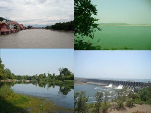
There are many river systems in India. They are one of the natural resources. There is diversity in their origin, direction of flowing and volume of water. Thus the rivers of India can be classified into two groups-rivers of North India and rivers of South India.
The Rivers of North India
The major river systems of North India are the Indus, the Ganga, the Brahmaputra and
their tributaries.The northern plains are fertile due to the deposition of alluvium carried by the rivers of north India.They are best for agricultural activities. The famous ancient historic and pilgrim centers are situated on the banks of these rivers. For example, Delhi, Agra, Varanasi etc.
The Rivers of South India :
These rivers can be divided into the east-flowing and the west-flowing rivers. The important
east-flowing rivers are the Mahanadi, the Godavari, the Krishna, the Kaveri, the Palar and the Pennar. They flow south east and eastwards and join the Bay of Bengal. The important
west flowing rivers are the Narmada, the Tapi, the Sharavathi, the Kali, the Netravathi, the Zuari and the Periyar. They flow westwards and join the Arabian Sea. These rivers are short
and swift, suitable for the generation of hydro-electricity as they have rapids and waterfalls.
Recently Ganga-Yamuna rivers have been heavily polluted which has affected their
purity.
The Climate of India
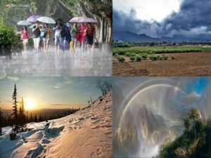
India has a tropical monsoon type of climate.The term monsoon is derived from the Arabic word Mousim meaning periodic. The specialty of the climate of India is that it changes from one season to another.
There are 4 seasons in India-winter season, summer season, south west monsoon season and retreating monsoon season.
The dry air, the changing monsoon winds and the natural hazards like cyclones adversely effect the climate of India.Consequently we find the sudden changes taking place in
the climate.The climate of India can be classified into 4 distinct seasons.
Seasons Duration (months)
- Winter :December, January, February
- Summer :March, April, May
- South-West monsoon(Rainy season/Kharif):June, July, August, September
- Retreating monsoon(Rabi season) October, November
The movement of air over the earth’s surface, from high pressure area to low pressure area is called wind. The winds which change their direction from one season to another are
known as seasonal winds. For Example, monsoon winds.
Diversity of plants and animals in India
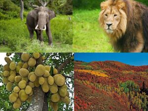
India has its own plant and animal resources. There are thick monsoon forests, grasslands, thorny bushes, scrubs,evergreen forests and mangrove forests. The deciduous forests are largely found in India. They are known as monsoon forests.
There are animal and bird sanctuaries, where elephants,tigers, lions, cheetas, bisons, deer, peacocks etc., and various birds are found. They are the major natural resources of India.